Sri Lanka, an island nation in South Asia, is strategically located in the Indian Ocean, southwest of the Bay of Bengal and southeast of the Arabian Sea. Separated from the Indian subcontinent by the Gulf of Mannar 1 and Palk Strait, Sri Lanka boasts numerous UNESCO World Heritage Sites. Colombo is its largest city, while Sri Jayewardenepura Kotte serves as the commercial capital.
Renowned for its rich cultural heritage, Sri Lanka is famous for its diverse dance forms, including Kandyan, Sabaragamuwa, and Low Country dances. Traditional music plays a vital role in theatrical performances like Kolam, Sokari, and Nagadam.
Sri Lanka's history is evident in its stunning art and architecture, with masterpieces like Mahavamsa paintings, Buddhist stupas, and ancient monastic residences. The Sri Lankan film industry shares similarities with Bollywood, reflecting the country's vibrant cultural tapestry.
Population: 47.9 million
🔗 Website: 🇱🇰 Sri Lanka Travel
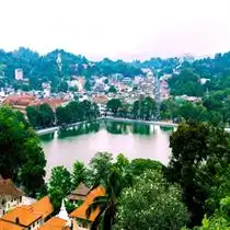
Capital: Sri Jayawardenepura Kotte (administrative), Colombo
Colombo overview: Colombo is a commercial hub with colonial buildings, markets, and beaches.
🔗 For more on Colombo click here
Population (Colombo, approx. 2025): 650,000
5 Primary cities:
🔗 Dehiwala-Mount Lavinia.
🔗 Moratuwa.
🔗 Negombo.
🔗 Kandy.
🔗 Galle.
✅ Plan your trip in one click: overview, currency, language, itinerary, attractions, hotels, cuisine, transport, weather & PDF export.
Sri Lanka's Enchanting Gems: Must-See Destinations for Your Bucket List

 Find your best Hotels, Flights, Bus & Other entertainments for Travel


🏨 Hotels
 HotelLook
 Choice Hotels
 Booking.com
 Hotels Combined
 Trip.com
 Accor Hotels
 Pierre et Vacances (French)
 Agoda Hotels
 Kyriad Hotels
 Campanile Hotels
✈️ Flights
 Lufthansa
 Etihad Airlines
 Air France
 Vistara Airlines
 CheapTickets
 CheapOAir
 Air Asia - Flight Bookings
 Singapore Airlines
 Cheapfareflights - Flight Bookings
 Flight Center
 Indigo Airlines Flight Bookings



🌟 Best Places to Visit in Sri Lanka

Sigiriya is also called as Sinhagiri. This is a prehistoric rock castle situated in the north of Matale District near Dambulla town, Sri Lanka. The King named Kashyapa was ruling here, he planned to build a palace at the top of the rock for his new capital and decorated the sides of palace by painting it in watercolors which is known as frescoes. The King also built an enormous Lion at the mid part of the rock. Sigiriya is now listed as one among the UNESCO Heritage Sites. Sinhagiri is preserved as a best example of urban planning.
Address: Rock Front, Sigiriya 21120, Sri LankaVisiting Hours: 07:00 am to 04:00 pm
Entry Fees: 4500 Rupees
🔗 Website: Official Sigiriya Rock Fortress (UNESCO)
✈️ Nearby Airports
Bandaranaike International Airport CMB 129.56 kmMattala Rajapaksa International Airport HRI 190.11 kmRatmalana Airport RML 158.63 km🚉 Nearby Railway stations
Habarana Dist:11.21 km┃Palugaswewa Dist:12.44 km┃Horiwiala Dist:15.22 km┃Minneriya Dist:19.14 km┃Kekirawa Dist:22.64 km┃Hatares Kotuwa Dist:22.68 km┃Galoya Junction Railway Station Dist:23.25 km┃Hathamuna Dist:24.09 km┃🚇 Nearby Bus Stops
Sigiriya Entrance Bus Station Dist:0.72 km┃Sigiriya bus stop Dist:0.90 km┃Bus stop Dambulla Dist:1.26 km┃Bus from Inamaluwa Dist:1.34 km┃Bus stop to Dambulla Dist:1.34 km┃
Galle is a main city in Sri Lanka, which is situated in the south-west tip, 119 km from Colombo. Galle is an administrative capital of Southern District, Sri Lanka and is the regional capital of Galle District. Portuguese gave an example of their unique architectural style and tradition by building a reinforced city Galle in the southern part of Asia. From 17th century (1649) Galle was strengthened by Dutch. This fort is one among the World Heritage Site and it will be preserved for European architecture.
Address: Galle, SrilankaVisiting Hours: December to April is the best time to visit
🔗 Website: Official Galle Fort (UNESCO)
✈️ Nearby Airports
Mattala Rajapaksa International Airport HRI 104.41 kmBandaranaike International Airport CMB 133.37 kmRatmalana Airport RML 95.64 km🚉 Nearby Railway stations
Katugoda Dist:2.71 km┃Richmond Hill Dist:3.35 km┃Unawatuna Dist:3.64 km┃Piyathigama Dist:4.17 km┃Ginthota Dist:5.62 km┃Boossa Train Station Dist:8.11 km┃Rathgama Dist:11.28 km┃Dodanduwa Dist:12.24 km┃Kumarakanda Dist:14.01 km┃Thiranagama Dist:15.55 km┃Seenigama Dist:19.96 km┃Midigama Dist:20.50 km┃Telwatte Dist:21.26 km┃Kumbalgama Dist:22.46 km┃Kahawe Dist:23.52 km┃Akurala Dist:24.94 km┃🚇 Nearby Bus Stops
Galle Highway Bus Stand Dist:0.70 km┃Direct express bus to Int. airport and Negombo 6:30 AM and 4:30 PM Dist:0.73 km┃Bus to Ella daily 6 a.m Dist:0.74 km┃Eramudugaha Junction Dist:3.43 km┃Unawatuna Dist:3.89 km┃Karapitiya Dist:4.59 km┃CTB Depot Dist:4.93 km┃Meegahawaththa Dist:4.97 km┃
The Royal Botanic Garden, Peradeniya is arranged 5.5km toward the west side of the city called Kandy in the focal area of Srilanka. This nursery is exceptionally close to Mahaweli waterway which is entranced by 2 million individuals who love to invest energy here and it draws in individuals with great assortment of orchids. Palm trees, orchids, Medicinal plants or more 4000 types of plants are shrouded in the recreation center. The territory of nursery is around 147 sections of land and 460 meters above ocean level, yearly precipitation is for 200 days. This Botanical Garden is very much kept up by the branch of the National Botanic Gardens of the division of farming. The nursery is extremely close to National Herbarium of Srilanka.
Address: Peradeniya Rd, Kandy, Sri LankaVisiting Hours: 08:00 am to 05:30 pm
Entry Fees: Adults Children (between 5-12 years) and students Rs. 600 (~$4.6) Rs. 300 (~$1.6)
Phone: +94 812 388 088
🔗 Website: Official Peradeniya Royal Botanic Gardens
✈️ Nearby Airports
Mattala Rajapaksa International Airport HRI 124.12 kmBandaranaike International Airport CMB 79.11 kmRatmalana Airport RML 92.68 km🚉 Nearby Railway stations
Rajawatta Dist:0.89 km┃Peradeniya Junction Dist:1.65 km┃Peradeniya Junction Dist:1.85 km┃Randal's Hill Dist:2.61 km┃Koshinna Dist:4.17 km┃Pilimatalawa Railway Staition Dist:4.76 km┃Asgiriya Dist:5.29 km┃Gelioya Train Station Dist:6.37 km┃Mawilmada Dist:6.62 km┃Katugastota Dist:7.78 km┃Polgahanga Dist:8.29 km┃Kadugannawa Dist:8.39 km┃Palle Talawinna Dist:9.00 km┃Uda Talawinna Dist:9.78 km┃Bothalapitiya Dist:10.86 km┃Meegammana Dist:11.03 km┃Balana Dist:11.73 km┃Kahatapitiya Dist:11.76 km┃Wattegama Dist:13.05 km┃Ihalakotte Dist:14.07 km┃Pattam Paha Dist:14.23 km┃🚇 Nearby Bus Stops
Shuttle bus station Dist:0.24 km┃Shuttle stop Dist:0.57 km┃Galaha Junction Dist:0.60 km┃Galaha Junction Dist:0.61 km┃Peradeniya Hospital Dist:0.63 km┃Peradeniya Dist:0.77 km┃Rajawatta Dist:0.84 km┃Peradeniya Dist:0.91 km┃Dangolla Junction Dist:1.02 km┃Polgahamula Dist:1.55 km┃Kehelwala Dist:1.69 km┃Bus to Kandy (until 6PM) Dist:1.78 km┃Owala Junction Dist:1.88 km┃Panideniya Dist:1.91 km┃Kohoalan Junction Dist:2.07 km┃Kiribathkumbura Dist:2.14 km┃Halloluwa Junction Dist:2.52 km┃Bowalawatta Dist:2.66 km┃Elagolla Dist:2.71 km┃Nanuoya Junction Dist:2.72 km┃Danasiri Dist:2.81 km┃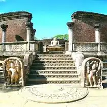
The Polonnaruwa Vatadage is an antique structure in the Kingdom of Polonnaruwa of Sri Lanka. The architecture of this era was considered as “ultimate development” described by the country. This structure is built to protect the small stupa. The whole building is decorated by stone carvings. During the rule of Parakramabahu I there is a consideration that Malla of Polonnaruwa to hold the contributions utilized by the Buddha. Both these loved relics would have given the structure an incredible hugeness and significance at the time. Relinquished for a few centuries, unearthing work at the Polonnaruwa Vatadage started in 1903.
Address: Polonnaruwa, Sri LankaVisiting Hours: 07:00 am to 08:00 pm
Entry Fees: 3750 Rupees
Phone: +94 272 222 222
🔗 Website: Official Polonnaruwa Ancient City (UNESCO)
✈️ Nearby Airports
Bandaranaike International Airport CMB 149.80 kmMattala Rajapaksa International Airport HRI 185.21 kmRatmalana Airport RML 175.26 km🚉 Nearby Railway stations
Parakum Uyana Dist:3.46 km┃Polonnaruwa Dist:4.02 km┃Laksha Uyana Dist:4.59 km┃Jayanthipura Dist:6.71 km┃Gallella Dist:8.27 km┃Hathamuna Dist:8.73 km┃Minneriya Dist:17.60 km┃Sevanapitiya Dist:20.38 km┃🚇 Nearby Bus Stops
Bus to Inamalluwa Dist:0.74 km┃Polonnaruwa Dist:0.80 km┃Bus 41 or 48 to Dambulla Dist:0.83 km┃Hospital Junction Dist:1.01 km┃New Town Dist:3.52 km┃SLTB Depot Dist:4.01 km┃Kaduruwela Dist:4.02 km┃
Yala National Park is the most visited and second greatest national park in Sri Lanka, flanking the Indian Ocean. The amusement focus contains five squares, two of which are by and by open to individuals as a rule, and adjoining parks. The squares have solitary names, for instance, Ruhuna National Park, and Kumana National Park or 'Yala East' for the flanking area. It is organized in the southeast area of the country and lies in Southern Province and Uva Province. The amusement focus spreads 979 square kilometers and is arranged around 300 kilometers from Colombo. Yala was allocated as a characteristic life shelter in 1900, and, nearby Wilpattu was one of the underlying two national stops in Sri Lanka, having been relegated in 1938. The amusement focus is best known for its collection of wild animals. It is critical for the security of Sri Lankan elephants, Sri Lankan pumas and maritime winged creatures.
Address: Katagamuwa, Yala, Sri LankaVisiting Hours: 06:00 am to 06:00 pm
Entry Fees: Entrance fee for foreigners is LKR 2,730
Phone: +94 112 888 585
🔗 Website: Official Yala National Park
✈️ Nearby Airports
Bandaranaike International Airport CMB 201.33 kmMattala Rajapaksa International Airport HRI 44.46 kmRatmalana Airport RML 186.71 km
It is the capital city of North Central Region, Sri Lanka and is known as capital of Anuradhapura District. Anuradhapura is one of the old capitals of Sri Lanka, acclaimed for its well-spared leftovers of an old Sinhala human headway. It was the third capital of the domain of Rajarata, following the domains of Tambapanni and Upatissa Nuwara. The city, by and by a World Heritage site, was the point of convergence of Theravada Buddhism for quite a while. The city lies 205 km (127 mi) north of the recurring pattern capital of Colombo in the North Central Province, on the banks of the prominent Malvathu River. It is one of the most settled reliably had urban territories on the planet and one of the eight World Heritage Sites of Sri Lanka.
Address: Anuradhapura, SrilankaVisiting Hours: April through September
Entry Fees: $25 USD per person to visit Anuradhapura
🔗 Website: Official Anuradhapura Sacred City (UNESCO)
✈️ Nearby Airports
Bandaranaike International Airport CMB 141.38 kmMattala Rajapaksa International Airport HRI 243.54 kmRatmalana Airport RML 178.52 kmMadurai International Airport IXM 301.40 km🚉 Nearby Railway stations
Anuradhapura School Dist:3.24 km┃Anuradhapura New Town Dist:3.54 km┃Srawasthipura Dist:5.77 km┃Saliyapura Dist:6.02 km┃Samagipura Dist:6.24 km┃Asokapura Dist:10.78 km┃Parasangaswewa Railway Station Dist:11.76 km┃Mihintale Dist:12.84 km┃Siyabalagawewa Dist:13.59 km┃Talawa Dist:13.77 km┃Madegama Dist:14.94 km┃Viralmurippuwa Dist:21.20 km┃Thambuttegama Dist:23.53 km┃Medawachchiya Dist:24.11 km┃🚇 Nearby Bus Stops
Library Dist:3.45 km┃Bus stop to Mihintale Dist:3.69 km┃
Mirissa is a community on the south shoreline of Sri Lanka, situated in the Matara District of the Southern Province. It is around 150 kilometers south of Colombo and is arranged at a rise of 4 meters above ocean level. Mirissa's seashore and nightlife make it a famous vacationer goal. It is additionally an angling port and one of the island's fundamental whale and dolphin watching areas. Mirissa is the biggest angling port on the south coast and is known for its fish, mullet, snapper and butterfish. In 1980 the main vacationer settlement was assembled anyway it wasn't until the mid-1990s that travel industry to the town began to drastically increment.
Address: Mirissa, Sri LankaVisiting Hours: 06:00 am to 09:00 pm
Entry Fees: Free
🔗 Website: Official Mirissa Whale Watching
✈️ Nearby Airports
Bandaranaike International Airport CMB 150.55 kmMattala Rajapaksa International Airport HRI 83.33 kmRatmalana Airport RML 115.39 km🚉 Nearby Railway stations
Polwathumodara Dist:1.93 km┃Mirissa Dist:2.62 km┃Kumbalgama Dist:4.92 km┃Midigama Dist:6.89 km┃Weherahena Dist:14.03 km┃Kekanadura Dist:16.39 km┃Bambaranda Dist:23.29 km┃Unawatuna Dist:23.82 km┃🚇 Nearby Bus Stops
Heanwala Junction Dist:1.48 km┃Palena Bus Station Dist:2.85 km┃Kamburugamuwa Junction Dist:4.83 km┃
Bentota is a beach front town in Sri Lanka, situated in the Galle District of the Southern Province, administered by a Urban Council. It is around 65 kilometers south of Colombo and 56 kilometers north of Galle. Bentota is arranged on the southern bank of the Bentota River mouth, at a rise of 3 meters over the ocean level. The name of the town is gotten from a legendary story which guarantees an evil spirit named 'Bem' administered the tota or stream bank. Bentota is a vacation spot, with a nearby air terminal (Bentota River Airport) and a bunch of world-class lodgings. Bentota likewise conveys an old specialty of recuperating called Ayurveda. Bentota is renowned for its hard stuff generation, a mixed refreshment made from coconut nectar. It likewise has a turtle incubation facility, situated on Induruwa seashore.
Address: Bentota, Sri LankaVisiting Hours: Open 24 Hours
🔗 Website: Official Bentota Beach Tourism
✈️ Nearby Airports
Mattala Rajapaksa International Airport HRI 125.12 kmBandaranaike International Airport CMB 85.40 kmRatmalana Airport RML 46.37 km🚉 Nearby Railway stations
Induruwa Dist:3.75 km┃Hettimulla Dist:4.31 km┃Mahainduruwa Dist:6.37 km┃Beruwala Dist:6.59 km┃Kosgoda Dist:9.62 km┃Maggona Dist:9.66 km┃Piyagama Dist:10.77 km┃Payagala Dist:11.57 km┃Ahungalla Dist:12.63 km┃Payagala North Dist:12.71 km┃Pathegamgoda Dist:14.42 km┃Katukurunda Dist:16.02 km┃Balapititya Dist:16.67 km┃Andadola Dist:17.87 km┃Kandegoda Dist:19.77 km┃Ambalangoda Railway Station Dist:21.41 km┃Madampagama Dist:24.07 km┃Waskaduwa Dist:24.54 km┃🚇 Nearby Bus Stops
Aluthgama Dist:1.35 km┃Bus Stop Dist:1.37 km┃
Nuwara Eliya is a city in the slope nation of the Central Province, Sri Lanka. Its name signifies "city on the plain (table land)" or "city of light". The city is the managerial capital of Nuwara Eliya District, with a beautiful scene and calm atmosphere. It is at an elevation of 1,868 m (6,128 ft) and is viewed as the most significant area for tea creation in Sri Lanka. The city is disregarded by Pidurutalagala, the tallest mountain in Sri Lanka. Nuwara Eliya is known for its calm, cool atmosphere – the coolest territory in Sri Lanka. The town truly wakes up in April for the Sinhalese and Tamil New Year. It is hard to discover convenience as Sri Lankans occasion in the district during this period. The merry season begins on April 1 yearly in a stylized way. The service comprises basically of a band appear in which all the neighborhood school groups take an interest.
Address: Nuwara Eliya, SrilankaVisiting Hours: February to May is the best time to visit Nuwara Eliya
🔗 Website: Official Nuwara Eliya Tourism
✈️ Nearby Airports
Bandaranaike International Airport CMB 100.19 kmMattala Rajapaksa International Airport HRI 85.37 kmRatmalana Airport RML 98.31 km🚉 Nearby Railway stations
Nanu Oya Dist:3.74 km┃Perakumpura Sub Railway Dist:5.41 km┃Radella Dist:6.03 km┃Great Western Dist:8.63 km┃Ambewela Dist:11.24 km┃Talawakele Dist:12.04 km┃Watagoda Dist:12.57 km┃Pattipola Dist:14.20 km┃kotagala railway station Dist:17.96 km┃Ohiya Dist:18.59 km┃Rozelle Dist:23.23 km┃Ihala Watawala Dist:24.87 km┃🚇 Nearby Bus Stops
Shed Dist:0.11 km┃Cinecita Dist:0.45 km┃Hatton Dist:0.57 km┃47-Kandy Dist:0.57 km┃79-Colombo (A/C) Dist:0.57 km┃Ragala/Udupessellawa Dist:0.57 km┃Nuawara Eliya Main Bus Station Dist:0.58 km┃47-Kandy-Kurunegala Dist:0.59 km┃749/1-Pattipola Dist:0.59 km┃79-Colombo Dist:0.59 km┃311-Badulla Dist:0.59 km┃Nanu Oya Dist:0.59 km┃749-Meepilimana Dist:0.60 km┃311-Welimada Dist:0.60 km┃Nanu Oya Junction Dist:0.72 km┃Gamini School Dist:0.85 km┃Gamini School Dist:0.88 km┃City Junction Dist:1.18 km┃Hawa Eliya Hospital Dist:1.58 km┃Gregory Lake Dist:2.02 km┃Blackpool Bridge Dist:2.11 km┃
Gangaramaya Temple is one of the most significant sanctuaries in Colombo, Sri Lanka, being a blend of present-day design and social pith. Situated on the Beira Lake, it was finished in the late nineteenth century. The sanctuary's design shows a mixed blend of Sri Lankan, Thai, Indian, and Chinese engineering. This Buddhist sanctuary incorporates a few monumental structures and is arranged not a long way from the tranquil waters of Beira Lake on a plot of land that was initially a little seclusion on a bit of muddy land. It has the fundamental highlights of a Vihara, the Cetiya the Bodhi tree, the Vihara Mandiraya, the Seema malaka (gathering lobby for priests) and the Relic Chamber. What's more, a gallery, a library, a private corridor, a three storeyed Pirivena, instructive lobbies and a donations lobby are likewise on the premises. Generally prominent for travelers is the engineering of the Simamalaka Shrine, which was worked with gifts from a Muslim support to the structure of Geoffrey Bawa.
Address: 61 Sri Jinarathana Rd, Colombo 00200, Sri LankaVisiting Hours: 06:00 am to 10:00 pm
Entry Fees: Free
Phone: +94 112 435 169
🔗 Website: Official Gangaramaya Temple Colombo
✈️ Nearby Airports
Mattala Rajapaksa International Airport HRI 156.45 kmBandaranaike International Airport CMB 29.37 kmRatmalana Airport RML 11.02 km🚉 Nearby Railway stations
Slave Island Railway Station Dist:1.17 km┃Kollupitiya Dist:1.23 km┃Maradana Railway Station Dist:1.66 km┃Colombo Fort Dist:2.06 km┃Secretariat Halt Dist:2.12 km┃Baseline Road Dist:2.52 km┃Bambalapitiya Dist:2.60 km┃Cotta Road Dist:2.95 km┃Narahenpita Dist:3.11 km┃Dematagoda Dist:3.30 km┃Kirulapona Dist:4.63 km┃Kelaniya Dist:6.38 km┃Dehiwala Dist:7.31 km┃Pangiriwatta Dist:7.53 km┃Wanawasala Dist:8.00 km┃Udahamulla Dist:8.23 km┃Hunupitiya Dist:9.21 km┃Nawinna Dist:9.68 km┃Enderamulla Dist:10.78 km┃Maharagama Dist:10.79 km┃Pannipitiya Dist:12.64 km┃🚇 Nearby Bus Stops
150 Dist:0.29 km┃NDB Dharmapala Mawatha Bus Stop Dist:0.36 km┃Colombo public library stop Dist:0.39 km┃Hyde Park Bus Stop Dist:0.39 km┃Ibbanwala Junction Bus Stop Dist:0.48 km┃Town hall Dist:0.54 km┃Town hall Dist:0.56 km┃Staple Street Bus Stop Dist:0.59 km┃Dharmapala Mawatha Halt Dist:0.62 km┃Townhall Bus Stop Dist:0.75 km┃Town Hall Dist:0.77 km┃Nawaloka Bus stop Dist:0.78 km┃Nelum Pokuna Dist:0.83 km┃Nawaloka Bus stop Dist:0.85 km┃Nawaloka bus stop Dist:0.87 km┃170 Athurugiriya, 190 Meegoda, 190 Godagama Dist:0.91 km┃Nelum Pokuna Bus Stop Dist:0.93 km┃Kollupitiya Market Halt Dist:0.97 km┃Liberty plaze Dist:0.97 km┃Sbc Nelum Pokuna Dist:1.00 km┃Kollupitiya Junction halt Dist:1.13 km┃
Dollar ($)
Euro (€)
Yen (¥)
Francs (CHF)
Sterling (£)
Renminbi (¥)
Rupee (₹)
Dollar ($)
Dollar ($)
🌍 Explore countries based on continents

United States

France

Japan

United Kingdom

India

South Africa

Brazil

Italy

Mexico

Russia

Vietnam

Argentina

Germany

China

Australia

Canada

Indonesia

Saudi Arabia

South Korea

Turkey

Spain

Singapore

Switzerland

Austria

Malaysia

Sri Lanka

Nepal

Portugal

Greece

Egypt

Israel

Thailand

Hong Kong

Macau

United Arab Emirates

Morocco

Tunisia

Senegal

Netherlands

Belgium

Ecuador

Poland

Hungary

Croatia

Ukraine

Czech Republic

Peru

Colombia

New Zeland

Kenya
